Floodplain & Drainage Modeling
Atlas Mapping Solutions produces RTK-supported elevation datasets for watershed analysis, drainage modeling, and floodplain studies using aerial LiDAR acquisition with the DJI M400 and Zenmuse L3 system. High-resolution bare-earth digital terrain models provide the vertical precision required for hydraulic modeling and flood risk assessment.

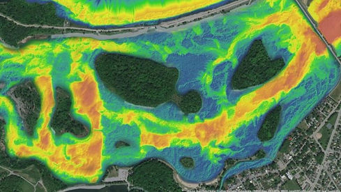
Elevation Data: Bare-earth DTMs support hydrologic modeling with vertical RMSE near 3 cm under optimal conditions.
Watershed Analysis: Flow direction, watershed boundaries, and stream networks are derived directly from terrain models and integrated into hydraulic software.
Deliverables: DTM, DSM, breakline-enhanced contours, channel cross-sections, flood mapping layers, and 2D/3D GIS outputs. Volumetric analyses for retention/detention areas are available.
Coverage & Timeline: Entire basins can be mapped in a few flights. Processing and QA typically require 1–2 weeks for regional studies.
Weather Considerations: Flights are conducted in dry conditions when possible to avoid surface water distortion.
Standards: Data quality supports FEMA/NFIP-aligned studies with checkpoint validation on stable surfaces.
Legacy vs LiDAR: Older flood studies relied on sparse contours or stereo imagery. LiDAR reveals micro-topography such as berms and minor channels that significantly influence flow modeling.